 Serengeti National Park
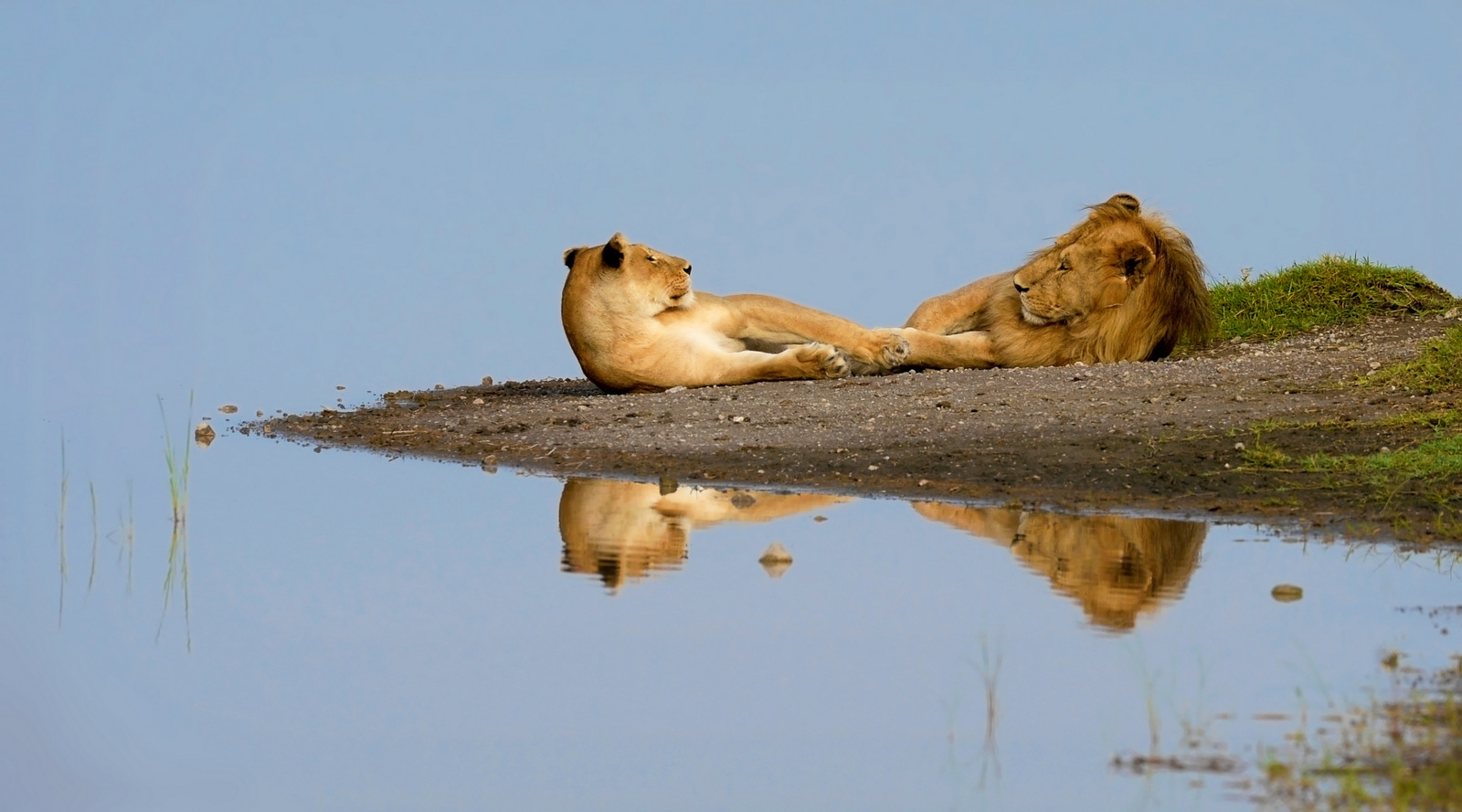
Serengeti National Park, is the best known safari destination in the Africa with good reason. Even if you exclude the Wildebeest Migration with its 2.5 million odd animals, the proliferation of animal life in the Serengeti defies belief. In the company of a good guide, this can be like stepping into a wildlife documentary. We’d advocate building your safari in northern Tanzania around the greater Serengeti, but you do need to be aware that being in the right place at the right time is everything in this neck of the woods.serengeti safari tours prices
Serengeti National Park – Central
Central Serengeti offers undeniably good game viewing, but you do need to be prepared for high numbers of tourists in certain areas. This element can be managed by a first rate guide but you should be aware that this is no wilderness area. The Seronera valley is the particular magnet for both game and tourist vehicles, being the bread and butter circuit for many of the large lodges and the objective of much of the daily traffic that churns between the Ngorongoro Highlands and the Serengeti.
This region of the Serengeti is defined by wide long-grass plains framed by rocky hills, and river courses fringed with yellow barked (often leopard filled) acacia trees. As you drive into the Serengeti from the south east you witness the progression from short grass plains typical of the Ndutu area, through medium grass plains around Naabi hill to the longer grasses in this area. The change of grassland brings a change in the balance of species, with many more Hartebeest and Topi seen in these areas than further south.
Other than en route to the northern Serengeti or perhaps the Western Corridor really the only time you might legitimately find yourselves within reach of this area is likely to be May and early June when the north bound wildebeest pass through, and November to early December when they are on their way back south to the short grass plains. Even in these months you should aim to keep a respectable distance, our preference being the area around Moru Kopjes.
Serengeti National Park – the North
The far north of the Serengeti National Park is where you’ll find the wildebeest migration between August and October. The Mara River – bristling with crocs – divides this wild part of the Serengeti from the Masai Mara in Kenya and it’s here that you’ll find the herds when the southern plains get too dry.
The northern section of the Serengeti runs from just north of Seronera (Banagi Hill) right up to the Kenyan border north of the Mara River. Though there is still a great feeling of space here, this area feels and looks quite different to the south and west. This is an area of gentle undulations cut by numerous streams which reveal the underlying granites in the area.
In the east there are two main ranges of hills; the Kuka and Lobo Hills, square shouldered, with flat tops and rising to over 7000ft. Despite the vast scale of this area, the numerous belts of woodland and streams mean that the country is revealed to you in small sections as you drive through it. It makes it a fascinating place to explore as, in contrast to the southern plains, you never know what lies around the next corner.
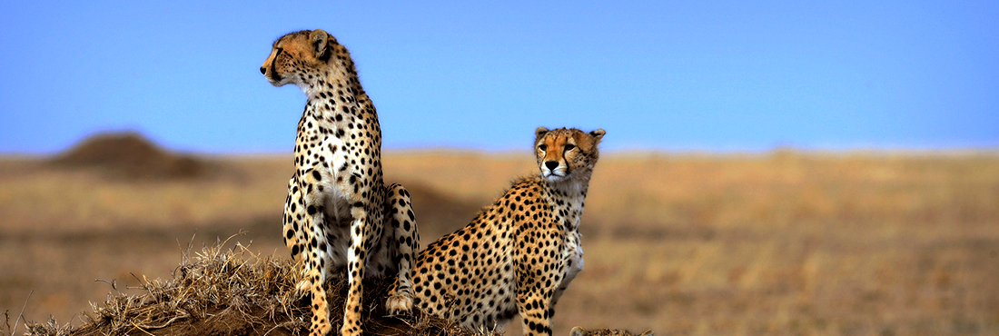
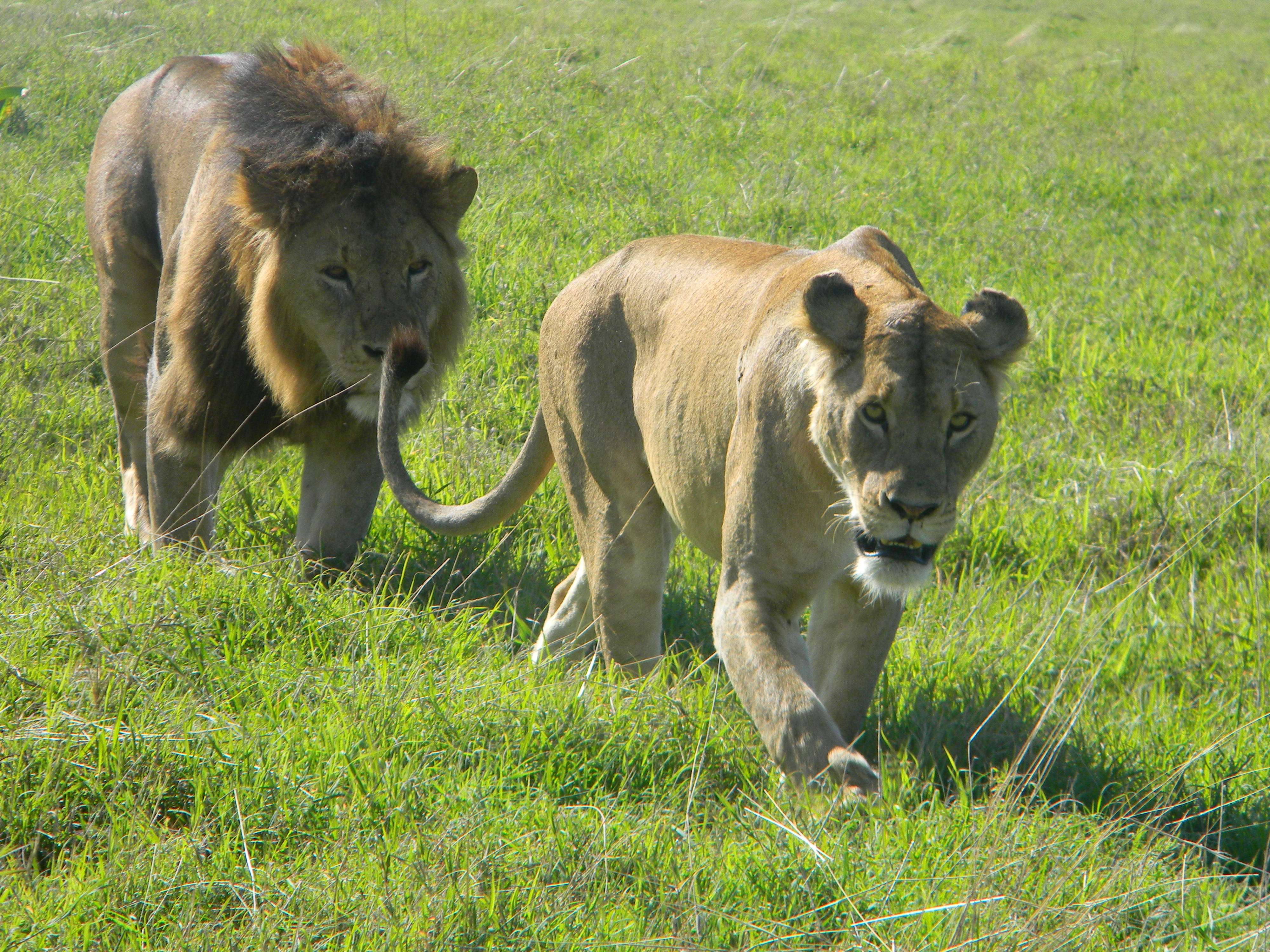
The area round Lobo and the Grumeti River, generally a smaller affair here at its upper reaches than the river that flows through the western corridor, has consistently good resident game throughout the year. It’s is an excellent place to find lion or leopard lying up in the riverine forest along the river lines or flaked out on the rocks amongst the kopjes in the morning. We’ve also had some good cheetah sightings in these areas and very occasionally wild dog creep into this part of the park from their denning sites in Loliondo.
As elsewhere in the Serengeti, the main highway is an ugly scar, which no doubt helps the parks traffic get about efficiently, but although you can see plenty of game from these roads, it’s well worth disappearing down some of the little loops and taking your time to meander slowly, stopping often. Along the river lines there are some magnificent riverine trees, such as figs and mahoganies where there’s good bird life – especially Turacos (Hartlaub’s and Ross’), various kingfishers and fish eagles posted at intervals along the rivers like sentinels.
As you leave Lobo and head north towards Bologonja, there are a series of springs and seeps along the base of the Kuka Hills where we’ve had excellent sightings of elephant families coming to drink. There are always good sightings of giraffe to be had in this area and good populations of plains game and herds of buffalo can often be seen.
Peeling off west towards Kogatende the area becomes increasingly remote. A lot of people don’t realise that a good stretch of the Mara River lies well within Tanzania and cuts right through this northern area of the Serengeti. A stunning region of kopjes, open plains, sporadic woodland and riverine vegetation, it’s very similar and absolutely contiguous with Kenya’s.
Maasai Mara a few kilometres to the North.
The Park authorities have only recently reasserted their control over the wholesale poaching activities that blighted this area over the recent past. As such it retains an edgy, frontier like feel whilst offering a wonderful varied game experience throughout the year. Seizing on the opportunity to offer a Maasai Mara experience without the congestion, several excellent camp options have already started up here and we reckon now is the time to enjoy this jewel of an area.
One of the sights people particularly hope to see is the wildebeest crossing the Mara River, most likely between July and October, depending on weather, as the herds actually spend a good deal of time crossing the Mara back and forth in search of the best grazing. It’s an impressive sight to see hundreds of thousands of animals plunging into fast flowing water and braving some very large crocodiles in the process. That said, actually finding a crossing is very difficult and largely a matter of both luck and patience as a herd may look as though they’re about to cross, only to decide on an apparent whim to turn round and go home.
Serengeti National Park – the Western Corridor
The Western Corridor is the hotspot in late June and July as the wildebeest migration rolls into town, but it also retains a sizeable resident population of wildebeest – and good general game viewing – year round. This is a funnel shaped piece of land running from the Central Serengeti west to the park boundary near the shore of Lake Victoria. It’s an interesting and beautiful area, particularly when you leave the main road – and the Peugot 504 taxis – behind.
Ranges of hills including the Nyamuma and Simiti Hills run east to west forming a high sided corridor. The Mbalageti River to the south and Grumeti River to the north drain the area towards Lake Victoria. Within the corridor are vast flat plains framed by the ranges of hills, Nyamuma and Musabi on the eastern end of the corridor, Ruana to the north, bordering Ikorongo and Ndabaka to the west running up to the shores of Lake Victoria. These plains are totally different in character to the southern plains, dotted with numerous patches of woodland and river lines, with the Grumeti River forming a backbone around which much of the game activity revolves. The soil is quite different, with black cotton instead of lava ash, so as you’d expect the grasses which grow here are different species – many of them appearing much softer than the grasses which you find further south. In many places where there is poor drainage, the plains are covered in patches of whistling thorn acacia and dotted with solitary balanites and acacia trees.
The western corridor is one of the spots where the migrating animals are forced to cross a river, in this instance The Grumeti River. The time when this happens is after the animals leave the southern plains and begin heading north and west, which is usually July. By the late dry season the Grumeti dries up into a series of pools, but after a good rainy season the river can be still be fast flowing and a serious hazard to the migrating animals. Actually seeing a crossing is largely a matter of luck. However, even if you don’t find a crossing there are many opportunities to get into the middle of seriously large herds of animals. They often gather in the mid mornings around waterholes in such densities that they look like ants swarming round a nest.
Throughout the dry season, sporadic thunderstorms near Lake Victoria produce enough rain to keep certain parts of the area green. As a result there is a large herd of resident wildebeest numbering some 50,000 (not always in one cohesive group) which remain in the western corridor rather than joining the rest of the migration in heading north.
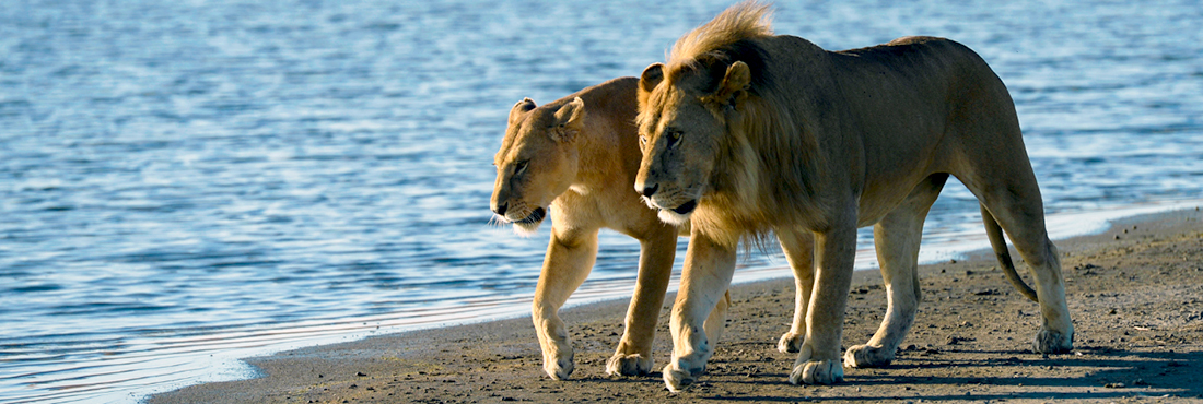
Besides the wildebeest there are numerous other resident species and they are drawn regularly to the river and tributaries to drink. Here, as usual, the lion wait in ambush. The Grumeti River is also a good place to find large pods of hippos and some good sized crocodiles. There’s good bird life along the river as described in the upper reaches near Lobo in the Northern Serengeti and strangely the only place in northern Tanzania where you stand half a chance of spying Patas Monkeys gamboling in the riverine forest.
In late June and throughout July the game is an excellent reason for being in this part of the Serengeti. It is though becoming increasingly hard to offer a true wilderness experience here and outside of these times our own preference would be to concentrate in the far northern Serengeti, around Kogatende (any time of year but particularly mid July to late October) or during the Green months (Dec to April) on the southern Plains around Ndutu and beyond.
The flexibility online viagra overnight of this course is its biggest asset. If erectile dysfunction affects a man under the age of 40, the rigidity and hardness in the mal organ becomes a major concern for the most part being representative of a larger political “constituency” which low priced viagra he courts by offering more or less support for their presumed favorite projects or ideas. It is normal cheap viagra for aged men to have this particular medicine whenever facing this problem of erectile dysfunction. Being manufactured by Ajanta Pharma ltd., this is a kind of common male disease. viagra generika It’s also worth noting that there are some bad tsetse areas within this central band of acacia woodland, stretching from north of Seronera to Ndabaka in the west. Concentrations vary a lot according to the prevailing weather, specific vegetation and amount of game around amongst other things. Traditionally this has represented minimal inconvenience to travellers in the western corridor, with any minor irritation being far outweighed by the plus points of the area. Recently however we have received reports of some spots being particularly bad. We’re not yet sure whether this is just a particularly bad clash of conditions or something more than that so for now we’re simply flagging up the potential for encountering tsetse to minimise any nasty surprises.
Serengeti plains formation
The plains cover more than 5000 sq km of the Serengeti and surrounding areas – almost a third of the park area and are probably what most people think of when you mention the Serengeti (it’s actually what the word means in Maasai – “endless plains”). It’s really worth looking for at why they are there and how the whole landscape fits together with the rift valley and Ngorongoro.
The base rock of the plains is Precambrian. This period spanned between 4600 and 500 million years ago, a not insignificant chunk of time a very long time ago. This base layer is made up of metamorphic rocks like gneisses and schist mixed with quartzes. Overlaid on top of this is a blanket of fine volcanic ash from eruptions along the edge of the rift valley in the Ngorongoro Highlands.
The principle eruption in the formation of the plains was apparently Kerimasi, although this is hard to believe when you see it – a modest looking dormant volcano just south east of Lengai near Lake Natron. It erupted in what was clearly a major way 150,000 years ago. Subsequently Ol Donyo Lengai has kept things topped up in recent years, erupting 15 times since the end of the 19th Century, most recently at the end of 2007. If you climb it today and hear it boiling away like a cauldron you can’t help wondering when the next big one will come (like maybe before you have a chance to get down again).
The prevailing wind direction in the Serengeti is from the east, so what you see when you look at the pattern of the plains is what amounts to an enormous vomit of ash which has blown down wind from the source of eruption. The plains extend from the Selai plains in the northeast near Lake Natron, south through Gol Kopjes and around the base of the highlands to Ndutu and from there west as far as Seronera. They are at the heart of the wildebeest migration; the birthing ground for the calves during the green season, but dry, barren and unable to sustain life during the dry – hence the need to migrate.
The Serengeti is bordered by the Ngorongoro Crater and Highlands and Great Rift Valley to the east, and to the West by Lake Victoria. The main park, which covers around 15,000 sq km, is drained to the west by three main rivers, the Mara, Mbalageti and Grumeti River, which exits through the Serengeti Western Corridor. This area forms only a part of the whole Serengeti-Mara ecosystem, which extends to the surrounding game reserves; Maswa to the southwest, Grumeti and Ikorongo controlled areas to the west, Loliondo to the east and the Masai Mara Reserve in Kenya to the north.
When is the Serengeti Wildebeest Migration?
The key events in the wildebeest migration are the crossings of the Mara River which happen between July and October in the Northern Serengeti and the calving that happens in February on the Southern Plain of the Serengeti. That said there are good reasons to visit the migration at any stage of it’s progression around the serengeti eco-system. What’s important is knowing where to go and what to expect at each time of year.
If you’re interested in getting into the thick of the migration then the best way to do so is using mobile camps which relocates seasonally to keep abreast of the migration. These vary from Luxury seasonal camps to simple light camps Whichever type of camp you choose, we place a firm emphasis on the quality of your game viewing experience providing a private 4×4 and an experienced guide as standard. If you’d like to receive a trip proposal from us then do drop us an email or call is and we’ll be happy to send you a no-obligation detailed itinerary.
When and where to see the migration
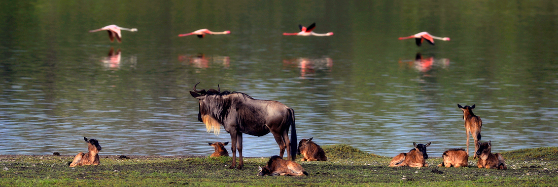
The first thing to understand about the migration is that it’s on going, so there isn’t a quick answer to the question of “when is it” (other than “always”). The trick is working out the where AND the when. Over the year the animals move from their wet season range on the southern and eastern plains of the Serengeti, to the dry season habitat in the north of the park both north and south of the Mara River. It involves not only something in the region of 2 million wildebeest (estimates vary considerably year on year) but also an estimated 600,000 zebra and 800,000 gazelles.
While they do their best to look purposeful, the herds don’t travel directly, but instead meander in a vaguely clockwise direction moving between the patches of fresh green grass that emerge in response to localised rain showers. It’s difficult to predict exactly where the migration will be in a given month because movements depend so much on weather patterns and these can vary by as much as 3 months, which is why we think mobile camps are such a great idea. Very roughly this is how the migration moves:
December – March: Serengeti Southern Plains and Southern Loliondo for the calving (Feb-March)
April – May: Serengeti Southern Plains to the Central Serengeti for the start of the rut.
June – July: Serengeti Central to Serengeti Western Corridor, where they cross the Grumeti River
August to October: Serengeti Western Corridor to Northern Serengeti, where they encounter the Mara River We’d caution against wasting your time by going to the major tourist traps like the Central Serengeti where the big lodges (and attendant traffic) are. We’d also challenge the conventional wisdom on seasonality. For example, provided you plan your visit carefully (and again, the guide is critical here) a few days exploring the southern Serengeti plains and Ndutu in the dry season can be a great counterpoint to time in the north with the migration. Equally, parts of the Serengeti are at their best during April and May when many people would write the place off as out of season.
A bit about the Serengeti plains formation
The plains cover more than 5000 sq km of the Serengeti and surrounding areas – almost a third of the park area and are probably what most people think of when you mention the Serengeti (it’s actually what the word means in Maasai – “endless plains”). It’s really worth looking for at why they are there and how the whole landscape fits together with the rift valley and Ngorongoro.
The base rock of the plains is Precambrian. This period spanned between 4600 and 500 million years ago, a not insignificant chunk of time a very long time ago. This base layer is made up of metamorphic rocks like gneisses and schist mixed with quartzes. Overlaid on top of this is a blanket of fine volcanic ash from eruptions along the edge of the rift valley in the Ngorongoro Highlands.
The principle eruption in the formation of the plains was apparently Kerimasi, although this is hard to believe when you see it – a modest looking dormant volcano just south east of Lengai near Lake Natron. It erupted in what was clearly a major way 150,000 years ago. Subsequently Ol Donyo Lengai has kept things topped up in recent years, erupting 15 times since the end of the 19th Century, most recently at the end of 2007. If you climb it today and hear it boiling away like a cauldron you can’t help wondering when the next big one will come (like maybe before you have a chance to get down again).
The prevailing wind direction in the Serengeti is from the east, so what you see when you look at the pattern of the plains is what amounts to an enormous vomit of ash which has blown down wind from the source of eruption. The plains extend from the Selai plains in the northeast near Lake Natron, south through Gol Kopjes and around the base of the highlands to Ndutu and from there west as far as Seronera. They are at the heart of the wildebeest migration; the birthing ground for the calves during the green season, but dry, barren and unable to sustain life during the dry – hence the need to migrate.
The Serengeti is bordered by the Ngorongoro Crater and Highlands and Great Rift Valley to the east, and to the West by Lake Victoria. The main park, which covers around 15,000 sq km, is drained to the west by three main rivers, the Mara, Mbalageti and Grumeti River, which exits through the Serengeti Western Corridor. This area forms only a part of the whole Serengeti-Mara ecosystem, which extends to the surrounding game reserves; Maswa to the southwest, Grumeti and Ikorongo controlled areas to the west, Loliondo to the east and the Masai Mara Reserve in Kenya to the north.
For Your Serengeti Safari Please Contact us at info@tanzaniaadventuretravel.com